Resource Exploration

Nevada Organic Phosphate Hits 33.7m Meade Peak, Strike Tops 4.5km

Image
Nevada Organic Phosphate Hits 33.7m Meade Peak, Strike Tops 4.5km

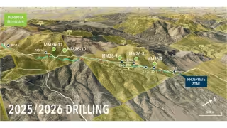
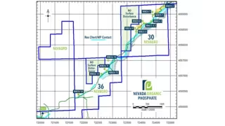
Vancouver – November 02, 2026 -- Nevada Organic Phosphate Inc. (CSE: NOP) intersected 33.7 metres (110.6 feet) of the target Meade Peak Member in drill hole MM26-13, extending the confirmed strike of the horizon to over 4.5 kilometres (2.8 miles) at its northeast Nevada project.

Core logging of MM26-13 noted oolitic zones typical of the Upper Phosphate Zone. True thickness and phosphate content remain unconfirmed until assays are returned.

MM26-14 intersects top of Meade Peak 1,036 metres from MM26-12

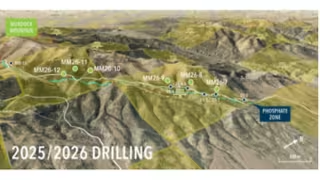
MM26-13 sits roughly 122 metres (397 feet) southeast of MM26-11 on the same section. Drilling is under way at MM26-14, which has just intersected the top of the Meade Peak. The hole lies 1,036 metres (3,400 feet) southwest of MM26-12.
Orvana Hits 116 g/t Gold at El Valle in H2 FY2026 Drilling

Image
Orvana Hits 116 g/t Gold at El Valle in H2 FY2026 Drilling

TORONTO – October 30, 2026 -- Orvana Minerals Corp. (TSX: ORV) reported a top intercept of 1.33 m at 116.41 g/t gold and 0.47% copper at its Breccia East zone in Spain. The hole sits within a 4.17 m interval grading 39.85 g/t Au and 0.34% Cu (DDH 26BX1094). The results come from 53 drill holes completed across the El Valle-Boinás and Carlés deposits in the second half of fiscal 2026, ended September 30, 2026.

Breccia East delivers 15.08 m at 10.68 g/t Au and remains open at depth

The El Valle-Boinás campaign totalled 6,537 metres, focused on oxide mineralized bodies. Breccia East accounted for 5,687 metres, Area 208 for 742 metres and Boinás East for 108 metres.

Nevada Organic Phosphate Extends Confirmed Strike to 3.5 km

Image
Nevada Organic Phosphate Extends Confirmed Strike to 3.5 km

Vancouver – October 21, 2026 -- Nevada Organic Phosphate Inc. (CSE: NOP) reported that drill hole MM26-12 intersected 37.4 metres (94.2 feet) of the target Meade Peak Member, extending the confirmed strike of the target zone to more than 3.5 kilometres (2.2 miles).

MM26-12 sits 200 metres southwest of MM26-11 along trend

The hole lies roughly 200 metres (656 feet) further southwest along trend from MM26-11. It is the company's western-most hole drilled to date. Core logging noted oolitic zones typical of the Upper Phosphate Zone.

The company has not yet confirmed the true thickness or phosphate content of the Upper Phosphatic Zone. Both depend on assay results, which are pending. The 37.4-metre figure is an intersection length, not a grade or resource estimate.

Lode Gold Completes Six Holes, Expands Fremont Drilling to 4,200 m

Image
Lode Gold Completes Six Holes, Expands Fremont Drilling to 4,200 m

Vancouver – October 19, 2026 -- Lode Gold Resources Inc. (TSXV: LOD) has completed six holes of its expanded 20-hole campaign at the Fremont Gold Mine in Mariposa County, California, and has lifted total planned drilling to 4,200 meters (13,780 feet) with ten additional holes.

First two holes already at the laboratory, assays pending

Samples from the first two holes have been submitted for analysis, and the company is awaiting assay results. Sample preparation and submission for the remaining holes will continue as drilling progresses. Lode Gold said it will report results once they have been received, reviewed and validated.

Six completed holes make up half of the 12-hole metallurgical program

The holes, designated PT-J_001 through PT-J_006, have planned target depths of roughly 105 to 171 meters (344 to 562 feet). They were designed with an azimuth of 240° and a dip of -75°.

NOP Hole MM26-11 Cuts 28.7m of Meade Peak Phosphate in Nevada

Image
NOP Hole MM26-11 Cuts 28.7m of Meade Peak Phosphate in Nevada

Vancouver – October 19, 2026 -- Nevada Organic Phosphate Inc. (CSE: NOP) reported that drill hole MM26-11 intersected 28.7 metres (94.2 feet) of the target Meade Peak Member in northeast Nevada, extending the confirmed strike length of phosphate mineralization to more than 3.3 kilometres.

MM26-11 steps out 315 metres southwest of MM26-10

The hole lies roughly 315 metres (1,037 feet) further southwest along trend from MM26-10. That hole in turn sits 1.5 kilometres (4,921 feet) along strike from MM26-9. Core logging noted oolitic zones typical of the Upper Phosphate Zone. True thickness and phosphate content have not yet been established and await assay.

Hycroft Hits Record 30.49 g/t Gold Over 19.6m at Vortex

Image
Hycroft Hits Record 30.49 g/t Gold Over 19.6m at Vortex

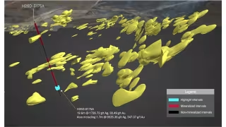
Winnemucca – October 14, 2026 -- Hycroft Mining Holding Corporation (Nasdaq: HYMC) drilled 19.6 meters grading 30.49 g/t gold and 1,726.72 g/t silver at its Vortex system in Nevada, the best hole in the company's more than 40-year history and the highest gold grades ever reported at Hycroft.

Hole H26D-6175A includes a 1.7-meter interval at 347.07 g/t gold

The high-grade core of the intercept returned 347.07 g/t gold and 9,526.36 g/t silver over 1.7 meters, with visible gold present. The result also marks the highest silver grades ever drilled at Vortex. The hole came from the 2025-2026 Exploration Drill Program.

H26D-6175A also intersected significant intervals of gold and silver mineralization along the full length of the hole, adding to mineralization within the resource.

Highlander Silver Maps Corani Targets Beyond Resource Footprint

Toronto – October 12, 2026 -- Highlander Silver Corp. (TSX, NYSE American: HSLV) reported that a geophysical study of its Corani Silver Project in Peru shows a mineral system far more extensive than historical drilling coverage, with untested potential to the west and south beneath shallow post-mineral cover. The company also reported an unaudited cash balance of about US$100 million and no debt.

Surveys cover over 90 km of IP-resistivity and 600 km of airborne magnetics

The study integrates historical datasets with the first airborne magnetic survey at Corani and more extensive induced polarization-resistivity surveys than previously undertaken. Highlander completed over 90 km of IP-resistivity and over 600 km of airborne magnetic surveys, and integrated the results with lithology, alteration and resource models, mapping and core logging data.

i-80 Gold's Mineral Point Drilling Signals Expansion Beyond 2025 PEA Resource

Image
i-80 Gold's Mineral Point Drilling Signals Expansion Beyond 2025 PEA Resource

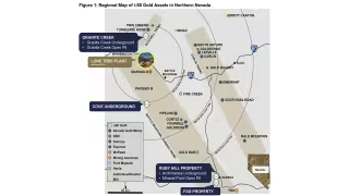
Nevada – September 22, 2026 -- i-80 Gold Corp. reported initial results from 35 drill holes at its Mineral Point open pit project in Nevada, with 19 step-out holes outside the existing mineral resource all encountering mineralization, over half returning more than 100 meters of gold and silver intercepts.

Step-out drilling extends mineralized footprint east of known deposit

Of the 35 holes reported, 15 step-out holes were drilled east of the deposit, three to the north, and one to the west. Tyler Hill, VP Geology, said initial results suggest potential to extend mineralization by approximately one kilometer along strike and 300 meters in width. The eastern zone was previously drilled sparsely by Homestake Mining Company in the early 1990s but was not advanced due to depth and gold price constraints at the time.

A2Gold Drilling Expands McIntosh Gold Zone in Nevada

Image
A2Gold Drilling Expands McIntosh Gold Zone in Nevada

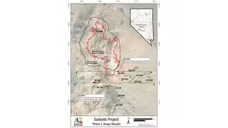
Tonopah, Nev. – September 20, 2026 -- A2Gold Corp. reported new reverse circulation drilling results at its McIntosh Target within the Eastside Gold-Silver Project, identifying a previously untested gold zone 370 metres southwest of the existing resource and extending known mineralization 86 metres to the southeast.

New drill hole intersects gold mineralization tied to untested magnetic anomaly

Hole ES-347 returned 0.23 g/t gold over 65.5 metres starting at 253.0 metres downhole, marking discovery of a new mineralized zone associated with a roughly 1.5-kilometre-long magnetic low anomaly that had not previously been drill-tested. The company said gold grades occur primarily along the margins of magnetic low anomalies, a pattern consistent with the geophysical signature of the existing McIntosh resource.

Purecore Metals Launches Data Review at Athabasca Basin Uranium Property

Image
Purecore Metals Launches Data Review at Athabasca Basin Uranium Property

Vancouver, BC – September 19, 2026 -- Purecore Metals Inc. (CSE: PURE) (FSE: J8Y) (OTCQB: PPURF) has commenced a comprehensive data compilation and technical review program at the Yurchison Uranium Property in the Athabasca Basin, northern Saskatchewan, a 35,029-hectare asset located approximately 75 kilometres south of Cameco Corporation's Rabbit Lake operation.

Purecore holds an option to earn up to 100% of the Skyharbour-optioned property

The Company holds an option to earn up to a 100% interest in Yurchison under a definitive agreement with Skyharbour Resources Ltd. (TSXV: SYH). The property comprises 22 claims and sits within the Wollaston Domain, underlain by Wollaston Supergroup metasedimentary gneisses adjacent to Archean granitic gneisses.