Energy Exploration

TGS wins rights to reprocess 11,000 km2 of Guinea-Bissau 3D seismic

Image

TGS wins rights to reprocess 11,000 km2 of Guinea-Bissau 3D seismic

Oslo – October 15, 2026 -- TGS has secured multi-client rights from state agency PetroGuin to reprocess more than 11,000 km2 of JAAN 3D seismic data across Guinea-Bissau, with final products due in Q4 2027.

TGS builds on 2019 reprocessing with new imaging tools

The agreement builds on the parties' previous 2019 PSDM reprocessing. TGS will apply elastic dynamic-matching full waveform inversion (E-DMFWI) and Kirchhoff pre-stack depth migration (KPSDM). The company expects a significant uplift in image quality compared with the existing data.

Improved imaging targets clastic and carbonate plays

The upgraded images are meant to improve assessment of both clastic and carbonate targets across the margin. TGS says this will give explorers greater confidence in evaluating prospectivity as they plan future exploration activity in Guinea-Bissau.
TGS, SLB Launch 11,200 sq km Pelotas Sul Phase 2 Survey Off Brazil

Image
TGS, SLB Launch 11,200 sq km Pelotas Sul Phase 2 Survey Off Brazil

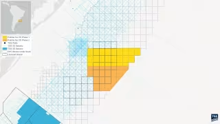
Oslo – October 13, 2026 -- TGS and joint venture partner SLB have announced Pelotas Sul Phase 2, a multi-client 3D survey covering approximately 11,200 square kilometers offshore southern Brazil, with a Ramform Titan-class vessel due to begin acquisition in October 2026.

Ramform Titan-class vessel to finish acquisition in Q2/Q3 2027

Data acquisition is scheduled to run from October 2026 to Q2/Q3 2027. The survey follows Pelotas Sul Phase 1, which was acquired earlier this year, and adds to TGS' 3D seismic coverage in the Pelotas Basin.

Namibia discoveries de-risk the frontier Pelotas Basin

TGS describes the Pelotas Basin as a frontier area that continues to attract industry interest. The basin is supported by geological analogs along the conjugate margin and de-risked by discoveries in Namibia.

TGS Wins Brunei Offshore Block Data Licensing Rights

Image
TGS Wins Brunei Offshore Block Data Licensing Rights

Oslo – October 11, 2026 -- TGS has been awarded data brokerage, marketing and licensing rights by the Petroleum Authority of Brunei Darussalam (PA) for subsurface data over an offshore Brunei block.

Award covers 3D seismic, well data and technical reports for one offshore block

The package includes 3D seismic data, well information and associated technical reports across the block. E&P companies can use the material to evaluate the acreage and reduce subsurface uncertainty before they take part in the block licensing process.

Brunei's PA targets international upstream investment

The project supports the Petroleum Authority's broader objective of attracting international investment into Brunei Darussalam's upstream sector. TGS says the award complements its existing multi-client footprint across the Asia Pacific region.

TGS Q3 Multi-Client Investment Falls to $63M; Q4 Vessels Booked

Image
TGS Q3 Multi-Client Investment Falls to $63M; Q4 Vessels Booked

Oslo – October 11, 2026 -- TGS expects multi-client investment of about USD 63 million in Q3 2026, down from USD 85.9 million in Q3 2025, according to its preliminary financial review.

OBN crew count of 2.2 beats expectations

The normalized Ocean Bottom Node (OBN) crew count for the third quarter was 2.2, slightly above company expectations. TGS completed two OBN contracts during the period: one in the Gulf of America for a client with which it has a long-term capacity agreement, and a node-on-a-rope contract in Europe.

North Sea project drags down streamer utilization

Streamer 3D vessel utilization came in below expectations, even though bookings were high going into the quarter. CEO Kristian Johansen attributed the shortfall to operational challenges on a North Sea multi-client project, which was completed in September.

TGS Launches Two Regional Seismic Products for Alaska's North Slope

Image
TGS Launches Two Regional Seismic Products for Alaska's North Slope

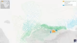
Oslo – October 11, 2026 -- TGS has launched two regional seismic products for Alaska, including a 2D-cubed volume that integrates roughly 667,640 square kilometers of data across the North Slope, Beaufort Sea and Chukchi Sea.

Great Bear Merge 3D stitches legacy surveys across 1,366 square miles

The Great Bear Merge 3D project combines multiple legacy seismic surveys into a single regional dataset covering approximately 1,366 square miles of Alaska's North Slope. TGS reprocessed the data with modern imaging technologies, including full-waveform inversion (FWI). The company says this improves data quality and continuity across historical survey boundaries.

The result is a consistent regional framework for evaluating exploration and development opportunities.